
Is El Niño Hitting the Pause Button?
(ZWZ26) (ZCZ26) (ZSX26) (WEAT) (CORN) (SOYB) (DBA) (TAGS) (SBH27) (CANE) (KCH27) (CCZ26) (CTZ26)
“Is El Niño Hitting the Pause Button?”

by Jim Roemer - Meteorologist - Commodity Trading Advisor - Principal, Best Weather Inc. & Climate Predict - Publisher, Weather Wealth Newsletter and Co-Producer of Climatelligence
Scott Mathews - Editor and Co-Producer of Climatelligence
October 27, 2026 - (original publication date for WeatherWealth subscribers was 10/19/26)
One of the fascinating things about predicting global weather is that ocean temperatures do not always tell the whole story. Sometimes the atmosphere sends a very different message!
While unusually warm equatorial Pacific Ocean temperatures suggest a potentially very strong, perhaps even super El Niño, two important atmospheric indicators are telling us something interesting: The atmosphere may temporarily be backing away from the powerful El Niño signal.
- 1) Global Angular Momentum (AAM): The Atmosphere’s Spinning Engine
Think of global atmospheric angular momentum as a measure of how Earth’s atmosphere rotates and how its winds redistribute momentum around the planet.
During many strong El Niño events, global AAM becomes unusually positive. Stronger subtropical jet streams and changes in tropical winds can help redistribute heat, moisture and storm systems around the world.
Our first chart shows AAM was exceptionally positive in September, approaching +5 on the displayed scale. However, forecasts now suggest a significant decline toward more neutral conditions by early November.
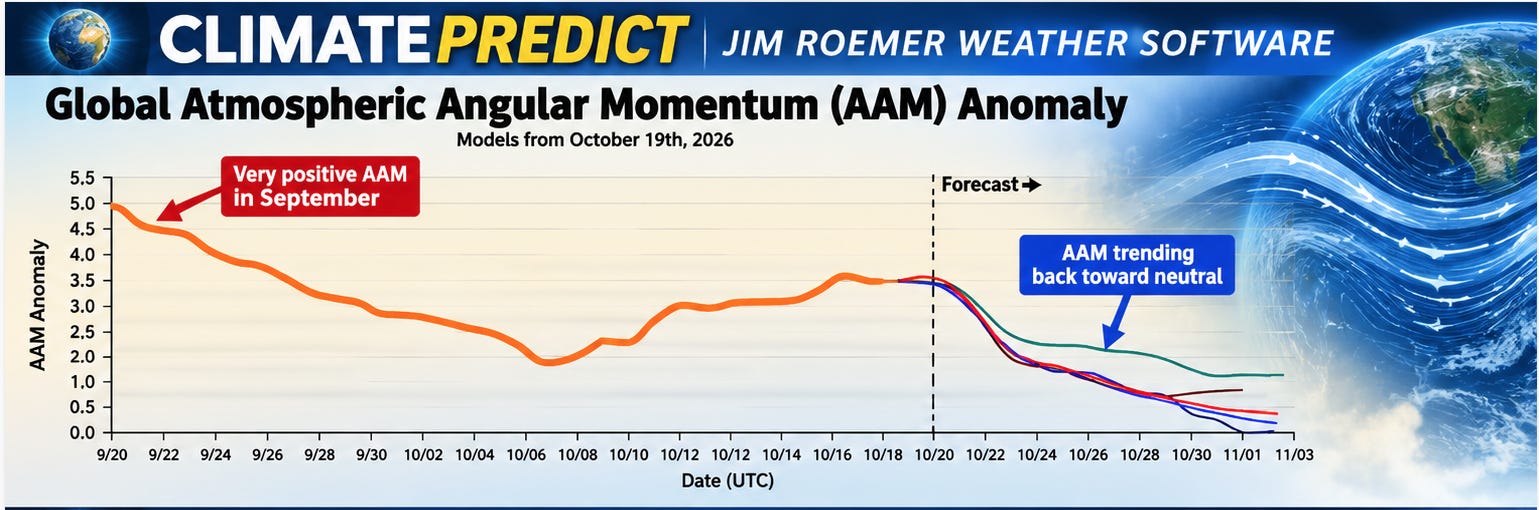
Why does this matter?
A declining AAM can signal changes in the jet stream, storm tracks and atmospheric circulation. This could temporarily alter rainfall patterns in Brazil, Argentina, Australia and parts of Asia, while also influencing U.S. winter temperature patterns.
However, AAM does not control the weather by itself. Its effects depend on where momentum is being added or removed and how other atmospheric patterns respond.
- 2) Southern Oscillation Index (SOI): Is El Niño Losing Atmospheric Support?
The SOI measures atmospheric pressure differences between Tahiti and Darwin, Australia.
Strongly negative SOI: Generally favors El Niño conditions, including weakened Pacific trade winds.
Strongly positive SOI: Generally favors La Niña conditions and stronger trade winds.
Near-zero SOI: Suggests a more neutral atmospheric pressure pattern.
Our second chart shows the SOI plunged toward -40 in September, an exceptionally strong atmospheric El Niño signal.
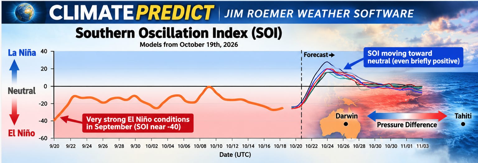
But look what happens next!
Forecast models indicate a sharp rebound toward neutral, with some solutions briefly turning positive during late October.
This suggests the atmospheric component of El Niño may temporarily weaken, even while Pacific Ocean temperatures remain exceptionally warm.
- 3) Does This Mean the Super El Niño Is Ending?
Not necessarily!
El Niño is an ocean-atmosphere phenomenon. Its strength is primarily classified by sustained sea-surface temperature anomalies in the central equatorial Pacific, particularly the Niño 3.4 region.
Traditionally, anomalies of +0.5°C or greater indicate El Niño conditions, while +1.5°C represents a strong event. The unofficial term “super El Niño” is often used for anomalies approaching or exceeding +2.0°C.
But these warm waters must be accompanied by sustained atmospheric coupling. A temporary SOI rebound or falling AAM does not establish that the oceanic event is weakening.
- 4) Why Commodity Traders Should Care
Changes in atmospheric circulation could influence:
Natural gas: U.S. jet-stream patterns and winter heating demand.
Soybeans and corn: Rainfall distribution across Brazil and Argentina.
Sugar and coffee: Tropical rainfall, drought, and harvesting conditions.
Wheat: Northern Hemisphere winter storm tracks and temperature extremes.
The following comments are by Editor Scott Mathews
Essentially, Jim’s “bottom line” can best be stated as follows:
The Pacific Ocean may still be shouting “Super El Niño,” but the atmosphere is beginning to whisper something different.
The key question is whether this atmospheric weakening is merely a temporary interruption or the beginning of a more persistent change.
For commodity traders, that distinction could be enormously important. This is precisely why our ClimatePredict forecast system examines multiple teleconnections rather than relying on ocean temperatures or traditional weather models alone.
Source: StormVista and Climate Predict AAM and SOI analyses and forecasts, October 19, 2026. Forecast changes are not yet observed outcomes.
The secret is understanding how climate signals interact—not simply assuming every El Niño means a warm winter.
The Fortune Cookie Message: “Never underestimate a stubborn climatological event!”
Receive frequent updates and trading ideas at our WeatherWealth newsletter. Request a free trial subscription HERE
ORGet occasional free updates and Climatepredict forecasts at our new Climatelligence newsletter here >>> climatelligence.substack.com
Jim Roemer, Scott Mathews, and the BestWeather Team
Mr. Roemer owns Best Weather Inc., offering weather-related blogs for commodity traders and farmers. He is also a co-founder of Climate Predict, a detailed long-range global weather forecast tool. As one of the first meteorologists to become an NFA-registered Commodity Trading Advisor, he has worked with major hedge funds, Midwest farmers, and individual traders for over 35 years. With a special emphasis on interpreting market psychology, coupled with his short-term and long-term trend forecasting in grains, softs, and energy markets, he holds a unique standing among advisors in the commodity risk management industry.